A to Z Definitions
A quick reference to PECS terminology
.
NOTES
All margin depictions are approximate.
As a general rule, Paths must satisfy Margins criteria and Margins must satisfy Path Criteria.
.
TERM / DEFINITION |
EXAMPLE |
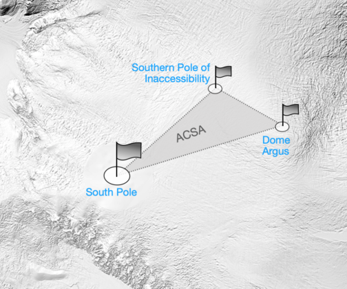
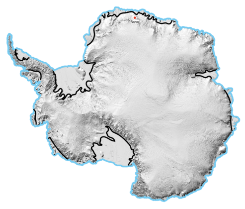
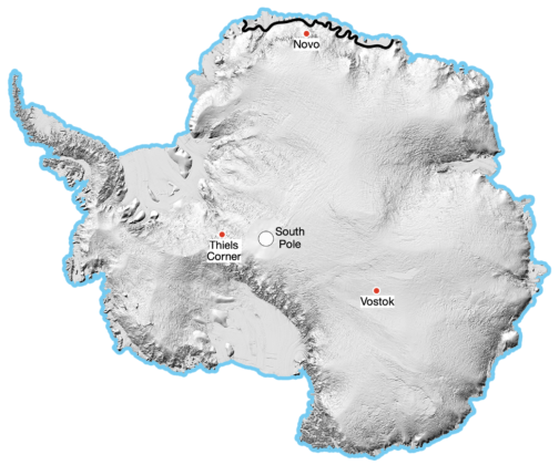
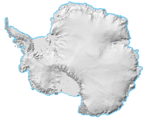
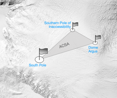
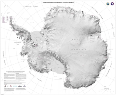
ACSA A triangular delineation in central Antarctica that connects South Pole (Axis), the outermost Pole of Inaccessibility (Centre) and the summit of Dome Argus (Summit) to form an Area. A Crossing of Antarctica must contact any point or points on the ACSA The ACSA is also a Margin |
 |
AID / AIDED A generic term for any support or assistance used between the start and end of a journey See also Support |
ALTERNATE RETURN EXPEDITION [Path Variant] An Expedition variant that travels out and back on a different route. The route has less than 90 degrees of arc between start and end eg. Ross Ice Shelf via Leverett Glacier to South Pole to Ross Ice Shelf via Axel Heiberg Glacier = Alternate Return South Pole Expedition Ward Hunt Island to North Pole to Greenland = Alternate Return North Pole Expedition Related variants:
|
 |
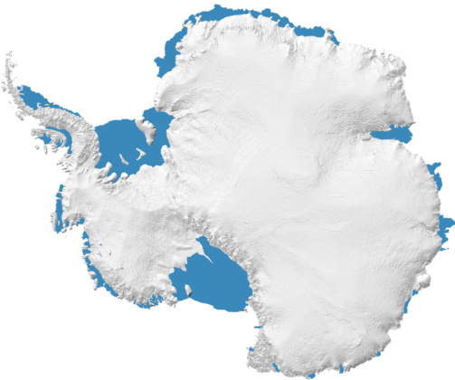
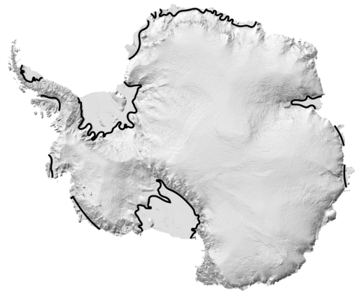
ANTARCTICA Antarctica is recognised by the Antarctic Treaty System as ‘the area below 60 degrees south latitude, including all ice shelves’. Ice shelves are an extension of Antarctic land ice and part of Antarctic geography and their outer perimeters, which are fronted by sea or annual sea ice, form part of the Antarctic coastline. |
 |
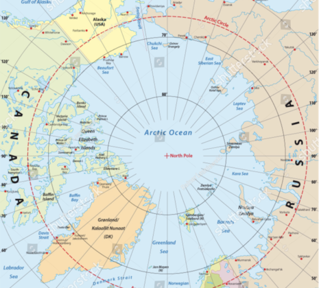
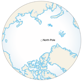
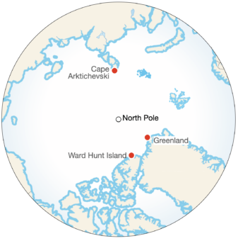
ARCTIC OCEAN The Arctic Ocean (sometimes referred to as the Arctic or Polar Sea) is located mostly in the Arctic north polar region in the middle of the Northern Hemisphere and is almost completely surrounded by Eurasia and North America |
 |
ASSISTANCE / ASSISTED A previous label used to describe the use of wind energy, dogs or machines for propulsion. |
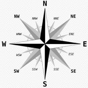
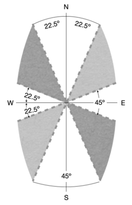
CARDINAL POINTS The four primary directions of North, South, West and East (NSWE) Intercardinals sit between each of the cardinals (NW, SE etc) |
 |
CIRCUMNAVIGATION [Path] The generic name for a Path that encircles a recognisable geographical feature. |
CIRCUMNAVIGATION [Path Variant] A Circumnavigation Variant that encircles the outside of a geographical feature and:
In the absence of Partial, Inner or Partial Inner in the label, Circumnavigation is implied Related variants:
|
 |
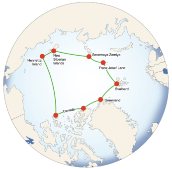
Circumnavigation of the Arctic Ocean A Path that touches land in Greenland, Canada, USA, Henrietta or New Siberia Islands, Severnaya Zemlya, Franz Josef Land and Svalbard. May be discontinuous (multi-season). |
 |
CLOSED LOOP [Path Variant] A Loop variant where the start and end points are the same. A Closed Loop is measured by:
Related variant:
|
|
COASTAL / COASTLINE [Margin] A generic term for any coastline that borders sea, sea ice, ice shelf or land See also Inner Coastal and Outer Coastal |
A Coastal Margin in Antarctica is any nautical or geographical coastline. 

Where Coastal is used without a qualifier (Inner or Outer), Outer Coastal is implied |
 |
| A Coastal Margin on the Arctic Ocean is any point on land |
 |
| A Coastal Margin in Greenland is sea level |
 |
COMMUNICATIONS Use of satellite phones, weather and ice forecasting and advisers on standby etc. are accepted forms of aid and not deemed as Support, unless used in combination with another form of aid. In many cases an expedition will not be permitted to proceed without multiple means of external communication. Inter-team communication is not considered Support, unless used in combination with another form of aid. Any journey communicating with the public is expected to use PECS. See Code of Integrity for advice on communications usage. |
CONTINUOUS An unbroken journey that has not been fragmented into multiple legs, expeditions or detached seasons See also Discontinuous |
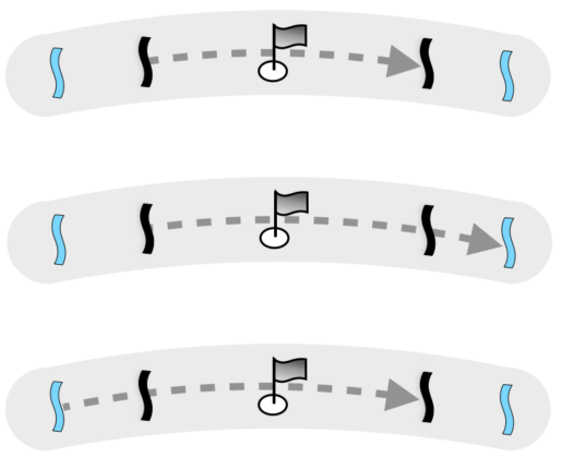
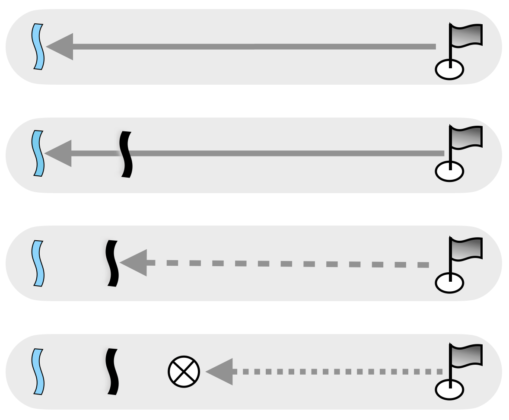
CROSSING [Path] A generic term for a Path that crosses from one margin to an opposite margin via a recognisable point. Traverse is sometimes used as an alternative term however Crossing is the preferred terminology and where Traverse is used, the Crossing definition will be applied. Related variants:
|
CROSSING [Path Variant] A Crossing variant that uses at least one Inner Coastal (Antarctica), Offshore (Arctic Ocean) or Inner Perimeter (Greenland) margin and does not use any Inland or Mid-Ocean margins Related variants:
|
 |
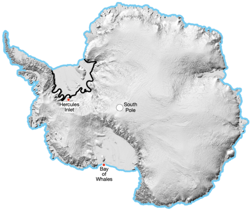
A Crossing of Antarctica
eg. Hercules Inlet to South Pole to Bay of Whales = Crossing of Antarctica |
 |
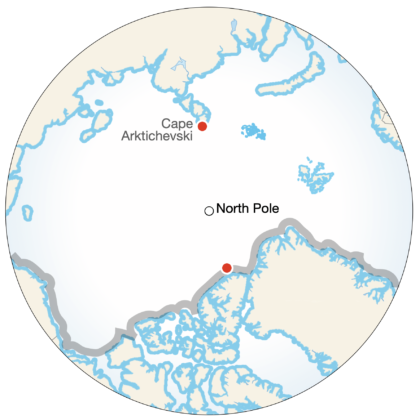
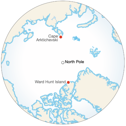
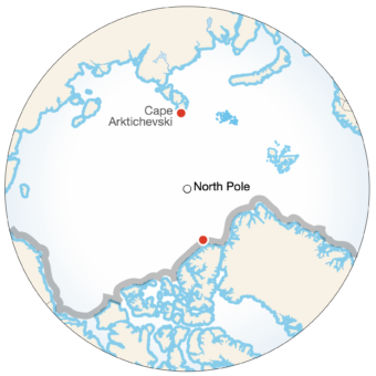
A Crossing of the Arctic Ocean
eg. Cape Arktichevski to 30km offshore from Canada = Crossing of the Arctic Ocean
A journey may not pre-plan an offshore start/end and claim a Crossing. |
 |
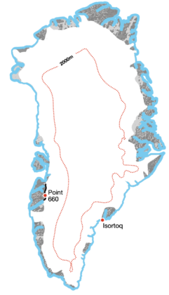
A Crossing of Greenland or its ice sheet
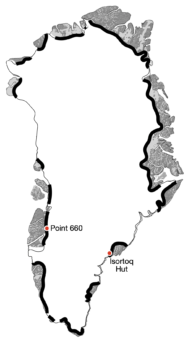
eg. Point 660 to Isortoq = Crossing of Greenland
See also Horizontal, Diagonal, Longitudinal and North-South Crossings of Greenland. |
 |
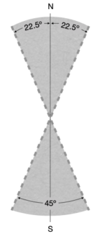
DIAGONAL CROSSING of GREENLAND [Path Variant] A Greenland Path variant where a straight line connecting the start and end points is greater than 22.5º angle in relation to true north/south and a line of latitude. Greenland Crossing variants:
Related Greenland Crossing variants:
|
 |
DISCONTINUOUS A journey broken across multiple legs, expeditions or detached seasons. Not continuous. A discontinuous journey is Supported. See also Continuous |
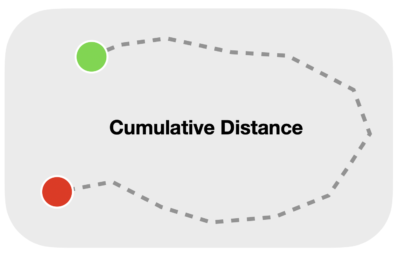
DISTANCES Calculation and recording A journey’s distance pre-expedition should be calculated from start to end and include major Path deviations. Standard routes such as Hercules Inlet to South Pole, Ward Hunt Island to North Pole and Point 660 to Isortoq coast across Greenland have recognised distances that should be used when promoting and immortalising journeys. Slight variants in these distances are acceptable. PECS’s standardised method of recording total distance is the tallying of camp location intervals, including start and end points. In addition journeys can record finer waypoint intervals eg. 30 minutes, however the camp to camp tally will be the accepted distance. Round-trips to retrieve a second sled or load should not be included in the tally. Journeys on the Arctic Ocean should record straight line distance and a camp to camp tally that will take into consideration overnight drift. |
DISTINCTION An Unsupported journey that has achieved a first gender, first route, first mode of travel or first unsupported. A Distinction may also be awarded at the discretion of the PECS Committee. |
DOGSLED [Mode of Travel] A Mode of Travel using dogs for propulsion. Dogsled participants are often on foot or skis however they may not claim Ski as a Mode of Travel as supplies are hauled by dogs. Doglsedding, Dogsledder |
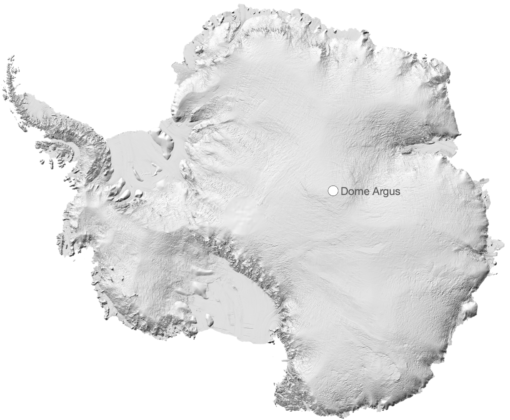
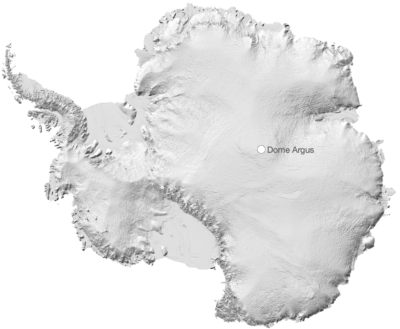
DOME ARGUS (Dome A) Situated in east Antarctica, Dome Argus is the largest ice dome in Antarctica and the summit of the Antarctic plateau. 4093m / 13,428’ (Ellipsoidal) elevation. POS 80°28.5762’S, 76°50.2296’E. Dome Argus is a corner point of the ACSA. |
 |
DOUBLE CROSSING [Path] A Crossing variant that crosses and returns to or towards its original start point, starting and ending on an inner coastline, inner perimeter or off-shore coastline . Double Crossings cannot be Discontinuous. eg. Point 660 to Isortoq to Point 660 = Double Crossing of Greenland Related Crossing variants:
|
 |
EVACUATION The removal of a soloist or team member by a third party during the course of a journey. Evacuation negates Unsupported status. |
EXPEDITION [Generic] Expedition is used as a generalised term for a journey, such as used in Polar Expeditions Classifications Scheme. |
EXPEDITION [Path] A Path that is not a Crossing, Circumnavigation or Loop. Related variants:
|
EXPEDITION [Path Variant] An Expedition Path variant that starts at an Inner Coastal (Antarctica), Offshore (Arctic Ocean) or Inner Perimeter (Greenland) margin and reaches a recognisable point Related variants:
|
 |
A journey that starts or ends on an Inner Coastline and reaches a recognisable point. eg. Hercules Inlet to South Pole = South Pole Expedition |
 |
Expedition on the Arctic Ocean A journey that starts or ends within 50km Offshore and reaches a recognisable point eg. 30km from Canada to North Pole = North Pole Expedition |
 |
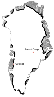
Expedition on Greenland A journey that starts or ends on the ice sheet perimeter and reaches a recognisable point. eg. Point 660 to Summit Camp = Greenland Expedition |
 |
FIRST MODE The first person or expedition to complete a journey using a new Mode of Travel |
FIRST PERSON The first person or journey to complete a new route or new mode of travel, or first gender |
FIRST ROUTE / NEW ROUTE A First/New Route must have an aesthetic quality as determined by the PECS Committee In Antarctica:
EXAMPLE - Ski from Bay of Whales to South Pole via untrodden Liv Glacier UNACCEPTABLE EXAMPLE - Ski from Pirrit Hills (near Patriot Hills) to South Pole On the Arctic Ocean:
In Greenland
EXAMPLE - Ski from Petermann Glacier to Isortoq UNACCEPTABLE EXAMPLE - Ski from Point 660 to Ikkatteq (just north of Isortoq) |
FOOT [Mode of Travel] A Mode of Travel that utilises footwear or any footwear attachment for a stepping gait such as walking or running |
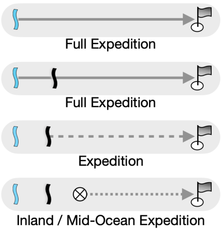
FULL A term used to denote a Full-Length/Width Expedition or Full-Length/Width Crossing. A historical tribute to early journeys that used ships to access start and end points. |
FULL CROSSING [Path Variant] A Crossing variant that starts and ends at opposite Outer Coastal (Antarctica) or Coastal (Arctic Ocean, Greenland) margins and passes a recognisable point Related variants:
|
 |
A Full Crossing of Antarctica:
eg. north Berkner Island to Bay of Whales = Full Crossing of Antarctica |
 |
A Full Crossing of the Arctic Ocean
eg. Cape Arktichevski to Ward Hunt Island = Full Crossing of the Arctic Ocean |
 |
A Full Crossing of Greenland or its ice sheet:
eg. Kangerlussuaq to Isortoq = Full Crossing of Greenland |
 |
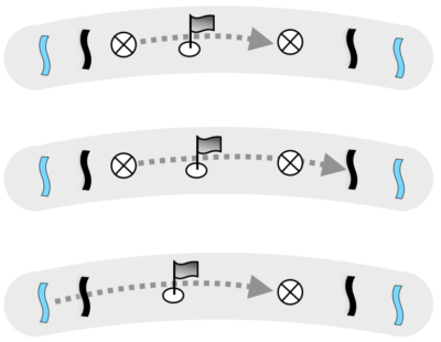
FULL EXPEDITION [Path Variant] An Expedition variant that starts at an Outer Coastal (Antarctica) or Coastal (Arctic Ocean, Greenland) margin and reaches a recognisable point Related variants:
|
 |
A Full Expedition on Antarctica
eg.
|
 |
A Full Expedition on the Arctic Ocean
eg.
Cape Arktichevski to North Pole = Full North Pole Expedition
North Pole to Ward Hunt Island = Full Reverse North Pole Expedition
Ward Hunt Island to North Pole to Ward Hunt Island = Full Return North Pole Expedition
Ward Hunt Island to North Pole to Greenland = Full Alternate Return North Pole Expedition
|
 |
A Full Expedition on Greenland
eg. Kangerlussuaq to Summit Camp = Full Summit Camp Expedition |
 |
GEOGRAPHICAL FEATURE Any recognisable feature that can be circumnavigated in its entirety eg. icecap, mountain range, ice dome at 3000m elevation, island, archipelago |
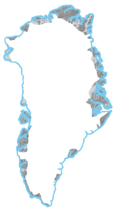
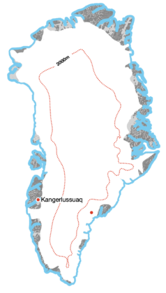
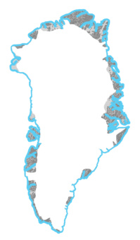
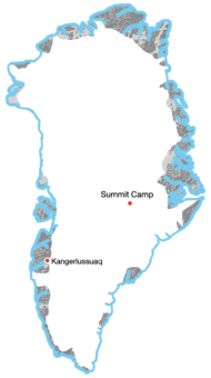
GREENLAND Greenland is the world's largest island, located between the Arctic and Atlantic oceans. Three-quarters of Greenland is covered by the world’s second largest ice sheet. |
GREENLAND DYE STATIONS Abandoned Distant Early Warning (DEW) Cold War radar stations. The DYE2 and DYE3 stations in Greenland offer historical interest and brief visits inside are not considered Support unless used as a weather shelter or removing artefacts (which could be used to repair equipment). |
GREENLAND ICE SHEET The ice sheet covering much of Greenland. Most journeys choose only to cross the ice sheet, a considerably less complex task than crossing the island coast to coast. |
GROUNDING LINE / GROUNDING ZONE A Grounding Line is the delineation at which glaciers start to float, however it is more of a zone due to tidal fluctuations. A Grounding Zone is the region where ice transitions from grounded icecap to freely floating ice shelf, typically over several kilometres. A journey using Inner Coastal Margins must be within the Grounding Zone. See also Margins |
GUIDED A guided journey is one that uses a guide or guides to manage and lead a team while the journey is underway. Guides often plan unique and committing journeys for their clients and as such a Guided journey is not classified as Supported unless it falls within Supported definitions. A Guided journey must make reference to its guided status in either the Label or Description. |
ICE CAP Generic term for a covering of ice over a large area |
ICE SHEET Geographical term for the world’s largest ice sheets including East Antarctic Ice Sheet, West Antarctic Ice Sheet and Greenland Ice Sheet. |
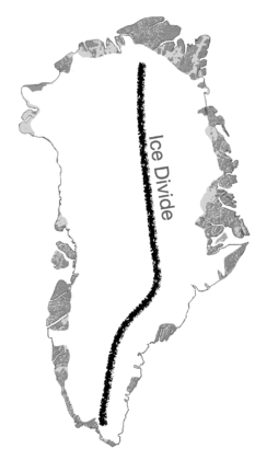
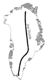
ICE DIVIDE OF GREENLAND The Greenland Ice Divide is the watershed ridge that runs north to south and divides the ice sheet into west and east. The northern perimeter is at 81.00N 40.00W and 2000m elevation, the southern perimeter is at DMS 61o55’48”N, 44o49’48”W; DMM 61o55.8’, 44o40.8: DM 61.93 -44.68 and 2500m elevation. These points should be rounded within a 5km radius. |
 |
ICE SHELF A floating sheet of fresh-water ice permanently or semi-permanently attached to a land mass. Ice shelves are an extension of land ice and their outer perimeters form part of the seaward coastline. Ice shelves also have a landward or inner coastline where they connect to land. Most of the world's ice shelves are in Antarctica, marked in blue. |
 |
INLAND ICE A term often used to describe the Greenland Ice Sheet |
INLAND / INSIDE [Margin] A Margin in Antarctica on land that does not start or end on any coastline and is on land. A Margin in Greenland that starts above the ice sheet perimeter |
INLAND CROSSING [Path Variant] A Crossing variant that uses at least one Inland margin Related variants:
|
 |
An Inland Crossing of Antarctica:
eg. Hercules Inlet to South Pole to Vostok = Inland Crossing of Antarctica |
 |
An Inland Crossing of Greenland:
eg. Start on the ice sheet above Isortoq to Kangerlussuaq = Inland Crossing of Greenland |
 |
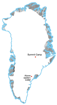
INLAND EXPEDITION [Path Variant] An Expedition variant that starts at an Inland (Antarctica and Greenland) margin and reaches a recognisable point. Related variants:
|  |
An Inland Expedition on Antarctica
eg. Novo to South Pole, Thiels Corner to South Pole, Vostok to South Pole = Inland South Pole Expedition
|
 |
An Inland Expedition on Greenland
|
 |
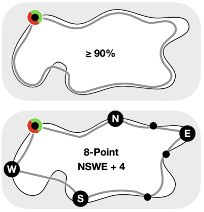
INNER CIRCUMNAVIGATION [Path Variant] A Circumnavigation variant that follows the inside of a geographical feature’s perimeter, such as a frozen lake or an icecap. An Inner Circumnavigation:
Where the perimeter or area cannot be measured the route should use an 8-Point System - contact the feature's cardinal extremes (northernmost, southernmost, westernmost and easternmost) and an additional 4 points to form 8 touching points spaced evenly around the perimeter. The start/end point may be one of the 8 points. Related variants:
|
 |
INNER COASTLINE [Margin] An Antarctic Margin indicated by the landward edge of an ice shelf
A journey using Inner Coastal Margins must be on or very close to the grounding zone where ice transitions from grounded icecap/glacier to freely floating ice shelf eg. Hercules Inlet, Messner Start Any journey starting or ending mid-ice shelf is designated as using an Inner Coastline. See also Outer Coastline |
 |
INNER PERIMETER [Margin] Any part of the Greenland ice sheet edge that is above sea level.
eg. Point 660, Isortoq Hut Any journey starting above sea level but below an inner perimeter assumes the criteria of an Inner Perimeter start. |
 |
JOURNEY A generic term for an unmotorised polar endeavour, also referred to generically as an expedition |
KEYWORDS A Label component eg. Unsupported, Crossing, Full, Ski etc |
KITE A wind-driven device used by Snowkiters and Wind-Craft sailors See also Snowkite |
KITE-SKI A former name for Snowkiting |
LABEL A synthesis of Keywords and an abbreviated Journey Description. Most commonly used to promote a journey. Labels are typically but not necessarily structured as follows:
|
LANDWARD COASTLINE [Margin] The edge of an ice shelf that touches land. An Inner Coastline. See also Inner Coastline and Seaward Coastline |
LAST DEGREE / DOUBLE DEGREE Highly commercialised expeditions that begin from 89 degrees (Last Degree) and 88 degrees (Double Degree) and travel to the North or South Poles. Treks of less than a degree are labelled, Within the Last Degree. Treks between 88 and 89 are labelled Within the Double Degree. |
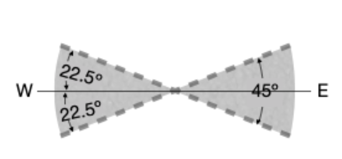
LATITUDINAL CROSSING of GREENLAND [Path Variant] A Greenland Crossing variant where a straight line connecting the start and end points is 22.5º angle or less in relation to a line of latitude Greenland Crossing variants:
Related Greenland Crossing variants:
|
 |
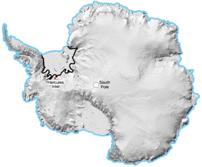
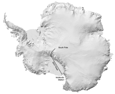
LEVERETT GLACIER The South Pole Overland Traverse (SPoT) road runs from McMurdo Station across the Ross Ice Shelf, up the Leverett Glacier and across the plateau to the South Pole. The road is graded at the beginning of each season and is permanently flagged. Any journey using the Leverett Glacier significantly mitigates risk and is therefore classified as Supported irrespective of whether it uses the SPoT road or not. See also SPoT Road |
LONGITUDINAL CROSSING of GREENLAND [Path Variant] A Greenland Crossing variant where a straight line connecting the start and end points is 22.5º angle or less in relation to true north/south. Greenland Crossing variants:
Related Greenland Crossing variants:
|
 |
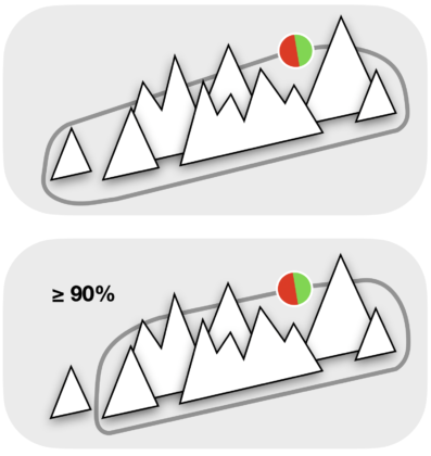
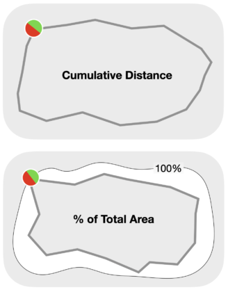
LOOP [Path] The generic term for a Path that encircles an undefined area and may be closed or open Loops are created from an accumulation of campsite locations including start and end |
LOOP [Path Variant] A Loop variant where the start and end points are different. A Loop is measured by:
Related variants:
|
 |
MANHAUL A traditional term for a common Mode of Travel using human power to haul supplies and equipment on a sled, most commonly on skis. |
MARGINS The start and end points of a journey, typically, but not necessarily, characterised by geography. Margins are not always obvious, particularly in Antarctica where coastlines are often buried, fluctuating or in hazardous locations. Any journeys using ill-defined coastlines are encouraged to thoroughly research start/end points that are in or as close as possible to broadly accepted grounding zones and be prepared to provide evidence of this research. Use of start/end points selected by previous journeys is not an assurance of accuracy. |
MECHANISED / MOTORISED Journeys using engines or motors for propulsion, for any part of the journey. Such journeys are not covered by PECS |
MID-OCEAN [Margin] An Arctic Ocean Margin that is more than 50km offshore  If an Arctic Ocean journey gains a Mid-Ocean Margin by sea-borne transport it may be Full if other Margins and Path criteria are met |
 |
MID-OCEAN CROSSING [Path Variant] A Path across the Arctic Ocean that:
eg. Cape Arktichevski to North Pole to 70km off Greenland Related variants:
See also Northern Poles Line |
 |
MID-OCEAN EXPEDITION [Path Variant] A Path on the Arctic Ocean to or from the Northern Poles Line that starts or ends mid-ocean eg. 70km off Greenland to North Pole = Mid-Ocean North Pole Expedition Related variants:
|
 |
MISCONDUCT A journey that is unauthorised or environmentally reckless |
MODE OF TRAVEL An unmotorised method of polar travel See also Supplementary Mode |
NEW ROUTE See First Route |
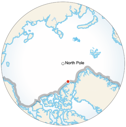
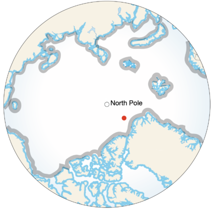
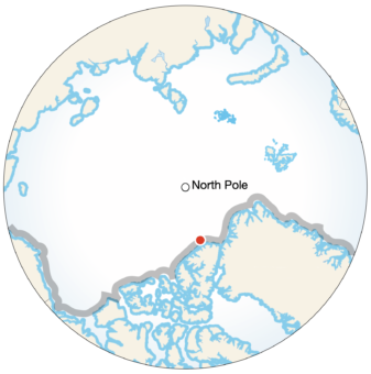
NORTH POLE The Geographic North Pole - 90º North. Defined as the point in the Northern Hemisphere where the Earth's axis of rotation meets its surface. The North Pole is a point on the Northern Poles Line. The North Pole is also a Margin |
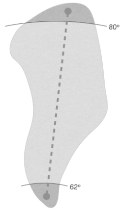
NORTH TO SOUTH or SOUTH-TO NORTH CROSSING of GREENLAND A Greenland Crossing variant where the start and end points are above and below latitudes 80º and 62º north respectively. Greenland Crossing variants:
Related Greenland Crossing variants:
|
 |
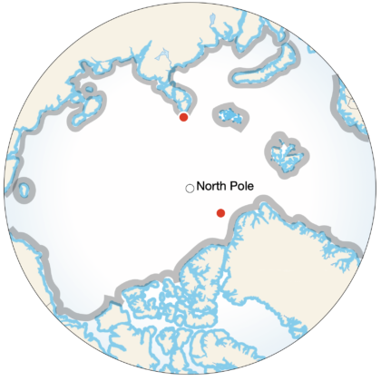
NORTHERN POLE OF INACCESSIBILITY (POI) The Northern Pole of Inaccessibility is the centre of the largest circle that can be drawn within the Arctic without encountering a coast - 85°48′N 176°9′W. Where a coast is imprecisely defined, the pole will be similarly imprecise. The Northern Pole of Inaccessibility is an end point of the Northern Poles Line. |
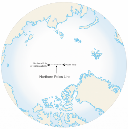 |
NORTHERN POLES LINE A direct line joining the North Pole and Northern Pole of Inaccessibility. A Crossing of the Arctic Ocean must touch any point on the NPL. The Northern Poles Line is also a Margin. |
|
OFF-LOADING Off-loading is the discarding or loss of equipment, food, fuel or rubbish between the start and end points of a journey. Off-loading that will negate Unsupported status:
Off-loading that will not negate Unsupported status:
|
OFFSHORE [Margin] A Margin on sea or annual sea ice that is within 50km of shore  |
|
OPEN LOOP [Path Variant] A Loop:
A loop is measured by tallying its camp to camp distances, including start and end points Related variants:
|
 |
OUTER COASTLINE [Margin] An Antarctic coastal Margin fronted by sea or annual sea ice. A Seaward Coastline. Sea or sea ice may not always be reachable. For example the seaward edges of many ice shelves are sheer cliff or heavy crevassing may prevent access in which case a journey should start/end as close as practically possible to sea or annual sea ice. See also Inner Coastline |
 |
PADDLE [Mode of Travel] A Mode of Travel that uses a watercraft propelled by paddling, usually combined with an on-ice Mode of Travel. Paddling, Paddler, Kayaking, Kayaker, Canoeing, Canoeist |
PARTIAL CIRCUMNAVIGATION [Path Variant] A Circumnavigation variant that:
In the absence of Partial in the label, Circumnavigation is implied Related variants:
|
 |
PARTIAL INNER CIRCUMNAVIGATION [Path Variant] An Inner Circumnavigation variant that:
In the absence of Partial in the label, Inner Circumnavigation is implied Related variants:
|
 |
PATH The geometry of a journey’s route between start and end |
PEDAL-DRIVE [Mode of Travel] A Mode of Travel using a pedal-drive device for propulsion. Pedal Driving, Pedal-Driver, Fat-Bike, Fat-Biking, Fat-Biker |
PERIMETER [Margin] Any geographical edge that forms a continuous and closed encirclement eg. the edge of an icecap, the shore of a continent, an island or ice shelf |
POLAR HAT-TRICK A Polar Hat-Trick is the completion of the three classic unmotorised polar routes. 1. Greenland Crossing or Full Crossing 2. South Pole Expedition or Crossing of Antarctica via the South Pole 3. North Pole Expedition or Crossing of the Arctic Ocean via the North Pole PECS Expedition and Crossing path definitions apply. The Expedition or Crossing may be Full but it may not be Inland/Mid-Ocean. |
RECOGNISABLE POINT / FEATURE Any distinctive geographic or mathematical point or feature eg. Greenland Ice Divide, Pole of Inaccessibility, 3000m contour line, Vostok Station |
RESUPPLY A form of Support where a journey benefits from an external resupply, cache or depot of food and/or equipment. |
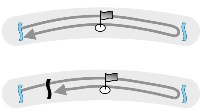
RETURN EXPEDITION [Path Variant] An Expedition variant that starts and ends at the same point or along the same line, reaching a recognisable feature or location at its furthermost point. Related variants:
|
 |
REVERSE EXPEDITION [Path Variant] An Expedition variant that starts at the North or South Pole or other recognisable feature or location and ends at or near a coastline. Related variants:
|
|
ROAD Any type of road, vehicle track or marked route. Unsupported journeys may not travel on roads except for short distances when crossing such tracks or when following routes into, out of or around bases, stations and camps as directed by authorities. The most prominent road is the SPoT Route in Antarctica however there are often very obvious tracks left by vehicles on other popular routes such as Union Glacier Camp to South Pole via Thiel Corner, much of it on the common Hercules Inlet to South Pole route, and the route from Novo to the plateau. See also SPoT Road |
ROUTE A line of travel described by a journey’s Path and Margins |
ROW [Mode of Travel] A Secondary Mode of Travel that uses a watercraft propelled by oar-locked paddling, usually combined with an on-ice Mode of Travel. Rowing, Rower. |
RUN A sub-category of Foot travel where a runner uses footwear or snowshoes, usually accompanied by a vehicle. Running, Runner. See also Foot |
SAIL [Mode of Travel] A Mode of Travel using a watercraft propelled by wind, usually combined with an on-ice Mode of Travel. Sailing, sailor |
SEAWARD COASTLINE [Margin] Any coastline fronted by sea or sea ice. An outer coastline in Antarctica See also Landward Coastline |
|
SELF-SUPPLIED A journey that caches food and or equipment en route that was part of the original load, and collects those same supplies on the return journey. Such a journey is Unsupported unless it fails to retrieve all of its caches, in which case it is a Supported journey. Any depot or cache that remains at or near the start point (start supply) and is later used to continue the same journey (eg. a return journey) is considered a resupply and a form of Support. A start supply is not considered a resupply if it remains in situ and is used while awaiting pickup from the same location. |
SKI [Mode of Travel] A Primary Mode of Travel using skis for the majority of a journey. Use of footwear, crampons or flotation devices may be used for short portions of the journey. Skiing, Skier |
SKI-SAIL A form of Snowkiting using shorter lines with less steerability. Also referred to as parawing sails or Beringer sails. Ski-Sailing, Ski-Sailor. |
SLED A small lightweight sliding device, either on runners or having a smooth bottom surface, used for hauling supplies and equipment over snow or ice. Also referred to as a pulk/pulka (Finnish/Norwegian) or sledge but more commonly as a verb, Sledging. Sledding. |
SNOWKITE [Mode of Travel] A Mode of Travel that uses a wind traction device to propel a skier or boarder, who may manually haul during sections of a journey. Snowkiting, Snowkiter. |
SNOWSHOE A sub-category of Foot travel using snowshoes as a method of locomotion. Snowshoeing, Snowshoer See also Foot |
SOLAR A journey relying exclusively on the sun’s energy for propulsion. Not yet classified under PECS. |
SOLO
In the absence of Solo in a label, Team is implied. |
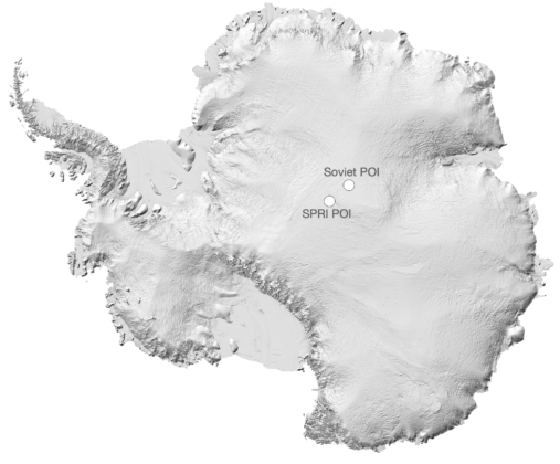
SOUTHERN POLE OF INACCESSIBILITY (POI) The centre of the largest circle that can be drawn within Antarctica without encountering a coast. Where a coast is imprecisely defined, the pole will be similarly imprecise. Two Poles of Inaccessibility can be located, with and with out the ice shelves. Without ice shelves: Soviet POI (Polyus Nedostupnosti) - 82°06′S 54°58′E With ice shelves: Scott Polar Research Institute (SPRI) POI - 85°50′S 65°47′E The Soviet POI is a corner point of the ACSA. |
 |
SOUTH POLE The Geographic South Pole. Defined as the point in the Southern Hemisphere where the Earth's axis of rotation meets its surface. The Geographic South Pole is a corner point of the ACSA. The South Pole is also a Margin |
 |
SPEED RECORD A speed record is the fastest time recorded on a route. A speed record must be:
The original and repeated journey must be Unsupported |
SPoT ROUTE The South Pole Overland Traverse (SPoT) route runs from McMurdo Station across the Ross Ice Shelf, up the Leverett Glacier and across the plateau to the South Pole. The road is permanently flagged and graded at the start of each season. Any similarly prepared and marked roads constructed in future will be considered Supported. |
 |
START/END POINTS See Margins |
SUPPLEMENTARY MODE Any additional Mode of Travel (eg. Paddle) that is planned, sustained and repetitive. Supplementary Modes should be included in the label eg. Ski-Paddle |
SUPPORT/SUPPORTED
Use of one or more of the above methods of support is Supported |
TEAM More than one person during any part of a journey. In the absence of Solo in the label, Team is implied. |
TRANSITORY ENCOUNTER A meeting of independent teams or individuals that is unplanned, brief or infrequent (Antonyms: not planned, sustained or repetitive). Should independent and unsupported teams be forced to camp in close proximity due to a confined camp area (eg. narrow valley, crevassed area) Encounters (including visits to tents belonging to unassociated expedition teams) should be transitory in order to maintain unsupported status. |
TRAVERSE An alternative term for a Crossing. Crossing is the preferred terminology and where Traverse is used, the Crossing definition will be applied. |
UNAIDED A generic heading that incorporates all forms of support and assistance. A previous label used to describe a journey that did not benefit from various forms of support such as resupplies. If Unaided is used by a journey the definition of Unsupported will be applied. |
UNASSISTED A word used previously to describe a journey that did not use wind energy, dogs or machines for propulsion. The word and any implied definition is not recognised or used by PECS. |
UNMECHANISED / UNMOTORISED A journey that does not directly use engines or motors for propulsion, for any part of the journey |
UNSUPPORTED A Journey that:
A journey must deny the use of all of the above to be classified as Unsupported. In the absence of the term Unsupported in the Label, Supported is implied. |
VARIATION of an existing route A Variation is any new course that does not qualify as a First/New Route eg. ski up Shackleton Glacier, exiting via Logie Glacier and continuing to South Pole |
WIND-CRAFT [Mode of Travel] A Mode of Travel that uses a wind traction device to propel a crewed craft. The craft may be manually hauled during sections of a journey. The most common sub-category of Wind-Craft is Windsled. Wind-Craft Sailing, Wind-Craft Sailor. |
WINDSLED A sub-category of Wind-Craft developed by Spaniard Ramon Larramendi and used on many successful journeys in Antarctica and Greenland |
A triangular delineation in central Antarctica that connects South Pole (Axis), the outermost Pole of Inaccessibility (Centre) and the summit of Dome Argus (Summit) to form an Area.
A Crossing of Antarctica must contact any point or points on the ACSA
The ACSA is also a Margin
A generic term for any support or assistance used between the start and end of a journey
See also Support
An Expedition variant that travels out and back on a different route. The route has less than 90 degrees of arc between start and end
eg.
Ross Ice Shelf via Leverett Glacier to South Pole to Ross Ice Shelf via Axel Heiberg Glacier = Alternate Return South Pole Expedition
Ward Hunt Island to North Pole to Greenland = Alternate Return North Pole Expedition
Related variants:
![ALTERNATE RETURN EXPEDITION [Path Variant] Example Image](https://pec-s.com/uploads/general/Paths/_small/PECS-Alternate-Return-Expedition.png)
Antarctica is recognised by the Antarctic Treaty System as ‘the area below 60 degrees south latitude, including all ice shelves’. Ice shelves are an extension of Antarctic land ice and part of Antarctic geography and their outer perimeters, which are fronted by sea or annual sea ice, form part of the Antarctic coastline.
The Arctic Ocean (sometimes referred to as the Arctic or Polar Sea) is located mostly in the Arctic north polar region in the middle of the Northern Hemisphere and is almost completely surrounded by Eurasia and North America

A previous label used to describe the use of wind energy, dogs or machines for propulsion
Where Coastal is used without a qualifier (Inner or Outer), Outer Coastal is implied

eg. Hercules Inlet to South Pole to Bay of Whales = Crossing of Antarctica

eg. Point 660 to Isortoq = Crossing of Greenland
See also Horizontal, Diagonal, Longitudinal and North-South Crossings of Greenland.
eg. north Berkner Island to Bay of Whales = Full Crossing of Antarctica
eg. Cape Arktichevski to Ward Hunt Island = Full Crossing of the Arctic Ocean

eg. Kangerlussuaq to Isortoq = Full Crossing of Greenland
eg.
eg.Cape Arktichevski to North Pole = Full North Pole ExpeditionNorth Pole to Ward Hunt Island = Full Reverse North Pole ExpeditionWard Hunt Island to North Pole to Ward Hunt Island = Full Return North Pole ExpeditionWard Hunt Island to North Pole to Greenland = Full Alternate Return North Pole Expedition
eg. Kangerlussuaq to Summit Camp = Full Summit Camp Expedition
eg. Hercules Inlet to South Pole to Vostok = Inland Crossing of Antarctica
eg. Start on the ice sheet above Isortoq to Kangerlussuaq = Inland Crossing of Greenlandi

eg. Novo to South Pole, Thiels Corner to South Pole, Vostok to South Pole = Inland South Pole Expedition

eg. above eastern icefall to Summit Camp = Inland Summit Camp Expedition
The four primary directions of North, South, West and East (NSWE)
Intercardinals sit between each of the cardinals (NW, SE etc)

The generic name for a Path that encircles a recognisable geographical feature
A Circumnavigation Variant that encircles the outside of a geographical feature and:
In the absence of Partial, Inner or Partial Inner in the label, Circumnavigation is implied
Related variants:
![CIRCUMNAVIGATION [Path Variant] Example Image](https://pec-s.com/uploads/general/Paths/_small/PECS-Circumnavigations.png)
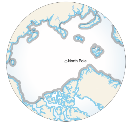
A Path that touches land in Greenland, Canada, USA, Henrietta or New Siberia Islands, Severnaya Zemlya, Franz Josef Land and Svalbard. May be discontinuous (multi-season)
A Loop variant where the start and end points are the same.
A Closed Loop is measured by:
Related variant:
![CLOSED LOOP [Path Variant] Example Image](https://pec-s.com/uploads/general/Paths/_small/PECS-Closed-Loop-variants.png)
A generic term for any coastline that borders sea, sea ice, ice shelf or land
See also Inner Coastal and Outer Coastal
Use of satellite phones, weather and ice forecasting and advisers on standby etc. are accepted forms of aid and not deemed as Support, unless used in combination with another form of aid. In many cases an expedition will not be permitted to proceed without multiple means of external communication.
Inter-team communication is not considered Support, unless used in combination with another form of aid.
Any journey communicating with the public is expected to use PECS.
See Code of Integrity for advice on communications usage.
An unbroken journey that has not been fragmented into multiple legs, expeditions or detached seasons
See also Discontinuous
A generic term for a Path that crosses from one margin to an opposite margin via a recognisable point. Traverse is sometimes used as an alternative term however Crossing is the preferred terminology and where Traverse is used, the Crossing definition will be applied.
Related variants:
A Crossing variant that uses at least one Inner Coastal (Antarctica), Offshore (Arctic Ocean) or Inner Perimeter (Greenland) margin and does not use any Inland or Mid-Ocean margins
Related variants:
![CROSSING [Path Variant] Example Image](https://pec-s.com/uploads/general/Paths/_small/PECS-Crossing.png)
A Greenland Path variant where a straight line connecting the start and end points is greater than 22.5º angle in relation to true north/south and a line of latitude.
Greenland Crossing variants:
Related Greenland Crossing variants:
![DIAGONAL CROSSING of GREENLAND [Path Variant] Example Image](https://pec-s.com/uploads/general/Paths/_small/PECS-Diagonal-Crossing.png)
A journey broken across multiple legs, expeditions or detached seasons. Not continuous. A discontinuous journey is Supported.
See also Continuous
A journey’s distance pre-expedition should be calculated from start to end and include major Path deviations.
Standard routes such as Hercules Inlet to South Pole, Ward Hunt Island to North Pole and Point 660 to Isortoq coast across Greenland have recognised distances that should be used when promoting and immortalising journeys. Slight variants in these distances are acceptable.
PECS’s standardised method of recording total distance is the tallying of camp location intervals, including start and end points. In addition journeys can record finer waypoint intervals eg. 30 minutes, however the camp to camp tally will be the accepted distance.
Round-trips to retrieve a second sled or load should not be included in the tally.
Journeys on the Arctic Ocean should record straight line distance and a camp to camp tally that will take into consideration overnight drift.
An Unsupported journey that has achieved a first gender, first route, first mode of travel or first unsupported. A Distinction may also be awarded at the discretion of the PECS Committee.
A Mode of Travel using dogs for propulsion. Dogsled participants are often on foot or skis however they may not claim Ski as a Mode of Travel as supplies are hauled by dogs.
Doglsedding, Dogsledder
Situated in east Antarctica, Dome Argus is the largest ice dome in Antarctica and the summit of the Antarctic plateau. 4093m / 13,428’ (Ellipsoidal) elevation. POS 80°28.5762’S, 76°50.2296’E.
Dome Argus is a corner point of the ACSA.
A Crossing variant that crosses and returns to or towards its original start point, starting and ending on an inner coastline, inner perimeter or off-shore coastline . Double Crossings cannot be Discontinuous.
eg. Point 660 to Isortoq to Point 660 = Double Crossing of Greenland
Related Crossing variants:
![DOUBLE CROSSING [Path] Example Image](https://pec-s.com/uploads/general/Paths/_small/PECS-Full-and-Double-Crossing.png)
The removal of a soloist or team member by a third party during the course of a journey. Evacuation negates Unsupported status.
Expedition is used as a generalised term for a journey, such as used in Polar Expeditions Classifications Scheme.
A Path that is not a Crossing, Circumnavigation or Loop.
Related variants:
An Expedition Path variant that starts at an Inner Coastal (Antarctica), Offshore (Arctic Ocean) or Inner Perimeter (Greenland) margin and reaches a recognisable point
Related variants:
![EXPEDITION [Path Variant] Example Image](https://pec-s.com/uploads/general/Paths/_small/PECS-Path-Expedition.png)
A journey that starts or ends on an Inner Coastline and reaches a recognisable point.
eg. Hercules Inlet to South Pole = South Pole Expedition
A journey that starts or ends within 50km Offshore and reaches a recognisable point
eg. 30km from Canada to North Pole = North Pole Expeditionex
A journey that starts or ends on the ice sheet perimeter and reaches a recognisable point.
eg. Point 660 to Summit Camp = Greenland Expedition
The first person or expedition to complete a journey using a new Mode of Travel
The first person or journey to complete a new route or new mode of travel, or first gender
A First/New Route must have an aesthetic quality as determined by the PECS Committee
In Antarctica:
EXAMPLE - Ski from Bay of Whales to South Pole via untrodden Liv Glacier
UNACCEPTABLE EXAMPLE - Ski from Pirrit Hills (near Patriot Hills) to South Pole
On the Arctic Ocean:
In Greenland
EXAMPLE - Ski from Petermann Glacier to Isortoq
UNACCEPTABLE EXAMPLE - Ski from Point 660 to Ikkatteq (just north of Isortoq)
A Mode of Travel that utilises footwear or any footwear attachment for a stepping gait such as walking or running
A term used to denote a Full-Length/Width Expedition or Full-Length/Width Crossing.
A historical tribute to early journeys that used ships to access start and end points.
A Crossing variant that starts and ends at opposite Outer Coastal (Antarctica) or Coastal (Arctic Ocean, Greenland) margins and passes a recognisable point
Related variants:
![FULL CROSSING [Path Variant] Example Image](https://pec-s.com/uploads/general/Paths/_small/PECS-Full-Crossing.png)
An Expedition variant that starts at an Outer Coastal (Antarctica) or Coastal (Arctic Ocean, Greenland) margin and reaches a recognisable point
Related variants:
Any recognisable feature that can be circumnavigated in its entirety eg. icecap, mountain range, ice dome at 3000m elevation, island, archipelago etc.
Greenland is the world's largest island, located between the Arctic and Atlantic oceans. Three-quarters of Greenland is covered by the world’s second largest ice sheet.
Abandoned Distant Early Warning (DEW) Cold War radar stations. The DYE2 and DYE3 stations in Greenland offer historical interest and brief visits inside are not considered Support unless used as a weather shelter or removing artefacts (which could be used to repair equipment).
The ice sheet covering much of Greenland. Most journeys choose only to cross the ice sheet, a considerably less complex task than crossing the island coast to coast.
A Grounding Line is the delineation at which glaciers start to float, however it is more of a zone due to tidal fluctuations.
A Grounding Zone is the region where ice transitions from grounded icecap to freely floating ice shelf, typically over several kilometres. A journey using Inner Coastal Margins must be within the Grounding Zone.
See also Margins
A guided journey is one that uses a guide or guides to manage and lead a team while the journey is underway. Guides often plan unique and committing journeys for their clients and as such a Guided journey is not classified as Supported unless it falls within Supported definitions. A Guided journey must make reference to its guided status in either the Label or Description.
Generic term for a covering of ice over a large area
Geographical term for the world’s largest ice sheets including East Antarctic Ice Sheet, West Antarctic Ice Sheet and Greenland Ice Sheet.
The Greenland Ice Divide is the watershed ridge that runs north to south and divides the ice sheet into west and east.
The northern perimeter is at 81.00N 40.00W and 2000m elevation, the southern perimeter is at DMS 61o55’48”N, 44o49’48”W; DMM 61o55.8’, 44o40.8: DM 61.93 -44.68 and 2500m elevation. These points should be rounded within a 5km radius.
Any type of road, vehicle track or marked route. Unsupported journeys may not travel on roads except for short distances when crossing such tracks or when following routes into, out of or around bases, stations and camps as directed by authorities.
The most prominent ice road is the SPoT Ice Road in Antarctica however there are often very obvious tracks left by vehicles on other popular routes such as Union Glacier Camp to South Pole via Thiel Corner, much of it on the common Hercules Inlet to South Pole route, and the route from Novo to the plateau.
See also Road
A floating sheet of fresh-water ice permanently or semi-permanently attached to a land mass. Ice shelves are an extension of land ice and their outer perimeters form part of the seaward coastline. Ice shelves also have a landward or inner coastline where they connect to land.
Most of the world's ice shelves are in Antarctica, marked in blue.

A term often used to describe the Greenland Ice Sheet
A Margin in Antarctica on land that does not start or end on any coastline and is on land.
A Margin in Greenland that starts above the ice sheet perimeter
A Crossing variant that uses at least one Inland margin
Related variants:
An Expedition variant that starts at an Inland (Antarctica and Greenland) margin and reaches a recognisable point.
Related variants:
![INLAND EXPEDITION [Path Variant] Example Image](https://pec-s.com/uploads/general/_small/Inland-Expedition.png)
A Circumnavigation variant that follows the inside of a geographical feature’s perimeter, such as a frozen lake or an icecap.
An Inner Circumnavigation:
Where the perimeter or area cannot be measured the route should use an 8-Point System - contact the feature's cardinal extremes (northernmost, southernmost, westernmost and easternmost) and an additional 4 points to form 8 touching points spaced evenly around the perimeter. The start/end point may be one of the 8 points.
Related variants:
![INNER CIRCUMNAVIGATION [Path Variant] Example Image](https://pec-s.com/uploads/general/Paths/_small/PECS-Inner-Circumnavigation.png)
An Antarctic Margin indicated by the landward edge of an ice shelf

A journey using Inner Coastal Margins must be on or very close to the grounding zone where ice transitions from grounded icecap/glacier to freely floating ice shelf
eg. Hercules Inlet, Messner Start
Any journey starting or ending mid-ice shelf is designated as using an Inner Coastline.
See also Outer Coastline
![INNER COASTLINE [Margin] Example Image](https://pec-s.com/uploads/general/Margins/Antarctica/_small/PECS-Margins-Inner-Coastlines-Antarctica.png)
Any part of the Greenland ice sheet edge that is above sea level.
eg. Point 660, Isortoq Hut
Any journey starting above sea level but below an inner perimeter assumes the criteria of an Inner Perimeter start.
An Inland Crossing of Antarctica:
eg. Hercules Inlet to South Pole to Vostok = Inland Crossing of Antarctica
A generic term for an unmotorised polar endeavour, also referred to generically as an expedition
A Label component eg. Unsupported, Crossing, Full, Ski etc
A wind-driven device used by Snowkiters and Wind-Craft sailors
See also Snowkite
A former name for Snowkiting
A synthesis of Keywords and an abbreviated Journey Description. Most commonly used to promote a journey.
Labels are typically but not necessarily structured as follows:
The edge of an ice shelf that touches land. An Inner Coastline.
See also Inner Coastline and Seaward Coastline
Highly commercialised expeditions that begin from 89 degrees (Last Degree) and 88 degrees (Double Degree) and travel to the North or South Poles. Treks of less than a degree are labelled, Within the Last Degree. Treks between 88 and 89 are labelled Within the Double Degree.
A Greenland Crossing variant where a straight line connecting the start and end points is 22.5º angle or less in relation to a line of latitude
Greenland Crossing variants:
Related Greenland Crossing variants:
![LATITUDINAL CROSSING of GREENLAND [Path Variant] Example Image](https://pec-s.com/uploads/general/Paths/_small/PECS-Horizontal-Crossing.png)
The South Pole Overland Traverse (SPoT) road runs from McMurdo Station across the Ross Ice Shelf, up the Leverett Glacier and across the plateau to the South Pole. The road is graded at the beginning of each season and is permanently flagged. Any journey using the Leverett Glacier significantly mitigates risk and is therefore classified as Supported irrespective of whether it uses the SPoT road or not.
See also SPoT Ice Road
A Greenland Crossing variant where a straight line connecting the start and end points is 22.5º angle or less in relation to true north/south.
Greenland Crossing variants:
Related Greenland Crossing variants:
The generic term for a Path that encircles an undefined area and may be closed or open
Loops are created from an accumulation of campsite locations including start and end
A Loop variant where the start and end points are different.
A Loop is measured by:
Related variants:
A traditional term for a common Mode of Travel using human power to haul supplies and equipment on a sled, most commonly on skis.
The start and end points of a journey, typically, but not necessarily, characterised by geography.
Margins are not always obvious, particularly in Antarctica where coastlines are often buried, fluctuating or in hazardous locations. Any journeys using ill-defined coastlines are encouraged to thoroughly research start/end points that are in or as close as possible to broadly accepted grounding zones and be prepared to provide evidence of this research. Use of start/end points selected by previous journeys is not an assurance of accuracy.
Journeys using engines or motors for propulsion, for any part of the journey. Such journeys are not covered by PECS
An Arctic Ocean Margin that is more than 50km offshore

If an Arctic Ocean journey gains a Mid-Ocean Margin by sea-borne transport it may be Full if other Margins and Path criteria are metm
![MID-OCEAN [Margin] Example Image](https://pec-s.com/uploads/general/Margins/Arctic/_small/PECS-Mid-Ocean-Margin.png)
A Path across the Arctic Ocean that:
eg. Cape Arktichevski to North Pole to 70km off Greenland
Related variants:
See also Northern Poles Line
![MID-OCEAN CROSSING [Path Variant] Example Image](https://pec-s.com/uploads/general/Paths/Arctic/_small/PECS-Path-Crossing-Mid-Ocean-Arctic-Ocean.png)
A Path on the Arctic Ocean to or from the Northern Poles Line that starts or ends mid-ocean
eg. 70km off Greenland to North Pole = Mid-Ocean North Pole Expedition
Related variants:
![MID-OCEAN EXPEDITION [Path Variant] Example Image](https://pec-s.com/uploads/general/Paths/Arctic/_small/PECS-Path-Expedition-Mid-Ocean-Antarctica.png)
A journey that is unauthorised or environmentally reckless
An unmotorised method of polar travel
See also Supplementary Mode
See First Route
The Geographic North Pole - 90º North. Defined as the point in the Northern Hemisphere where the Earth's axis of rotation meets its surface.
The North Pole is a point on the Northern Poles Line.
The North Pole is also a Margin
A Greenland Crossing variant where the start and end points are above and below latitudes 80º and 62º north respectively.
Greenland Crossing variants:
Related Greenland Crossing variants:

The Northern Pole of Inaccessibility is the centre of the largest circle that can be drawn within the Arctic without encountering a coast - 85°48′N 176°9′W. Where a coast is imprecisely defined, the pole will be similarly imprecise.
The Northern Pole of Inaccessibility is an end point of the Northern Poles Line.

A direct line joining the North Pole and Northern Pole of Inaccessibility.
A Crossing of the Arctic Ocean must touch any point on the NPL.
The Northern Poles Line is also a Margin.
Off-loading is the discarding or loss of equipment, food, fuel or rubbish between the start and end points of a journey.
Off-loading that will negate Unsupported status:
Off-loading that will not negate Unsupported status:
NOTE: due to the sub-optimal handling of waste in Greenland all rubbish collected on Greenland journeys should be flown out
A Margin on sea or annual sea ice that is within 50km of shore

![OFFSHORE [Margin] Example Image](https://pec-s.com/uploads/general/Margins/Arctic/_small/PECS-Margins-Arctic-Ocean.png)
An Antarctic coastal Margin fronted by sea or annual sea ice. A Seaward Coastline.
Sea or sea ice may not always be reachable. For example the seaward edges of many ice shelves are sheer cliff or heavy crevassing may prevent access in which case a journey should start/end as close as practically possible to sea or annual sea ice.
See also Inner Coastline
![OUTER COASTLINE [Margin] Example Image](https://pec-s.com/uploads/general/Margins/Antarctica/_small/PECS-Margins-Coastline-Antarctica.png)
A Mode of Travel that uses a watercraft propelled by paddling, usually combined with an on-ice Mode of Travel.
Paddling, Paddler, Kayaking, Kayaker, Canoeing, Canoeist
A Circumnavigation variant that:
In the absence of Partial in the label, Circumnavigation is implied
Related variants:
![PARTIAL CIRCUMNAVIGATION [Path Variant] Example Image](https://pec-s.com/uploads/general/Paths/_small/PECS-Partial-Circumnavigation.png)
An Inner Circumnavigation variant that:
In the absence of Partial in the label, Inner Circumnavigation is implied
Related variants:
![PARTIAL INNER CIRCUMNAVIGATION [Path Variant] Example Image](https://pec-s.com/uploads/general/Paths/_small/PECS-Partial-Inner-Circumnavigation.png)
The geometry of a journey’s route between start and end
A Mode of Travel using a pedal-drive device for propulsion.
Pedal Driving, Pedal-Driver, Fat-Bike, Fat-Biking, Fat-Biker
Any geographical edge that forms a continuous and closed encirclement eg. the edge of an icecap, the shore of a continent, an island or ice shelf
A Polar Hat-Trick is the completion of the three classic unmotorised polar routes.
1. Greenland Crossing or Full Crossing
2. South Pole Expedition or Crossing of Antarctica via the South Pole
3. North Pole Expedition or Crossing of the Arctic Ocean via the North Pole
PECS Expedition and Crossing path definitions apply. The Expedition or Crossing may be Full but it may not be Inland/Mid-Ocean.
Any distinctive geographic or mathematical point or feature eg. Greenland Ice Divide, Pole of Inaccessibility, 3000m contour line, Vostok Station
A form of Support where a journey benefits from an external resupply, cache or depot of food and/or equipment.
See also Start Supply
An Expedition variant that starts and ends at the same point or along the same line, reaching a recognisable feature or location at its furthermost point.
Related variants:
![RETURN EXPEDITION [Path Variant] Example Image](https://pec-s.com/uploads/general/Paths/_small/PECS-Paths-Return-Expeditions-Variants.png)
An Expedition variant that starts at the North or South Pole or other recognisable feature or location and ends at or near a coastline.
Related variants:
![REVERSE EXPEDITION [Path Variant] Example Image](https://pec-s.com/uploads/general/Paths/_small/PECS-Paths-Reverse-Expeditions-Variants.png)
Any type of road, vehicle track or marked route. Unsupported journeys may not travel on roads except for short distances when crossing such tracks or when following routes into, out of or around bases, stations and camps as directed by authorities.
The most prominent ice road is the SPoT Ice Road in Antarctica however there are often very obvious tracks left by vehicles on other popular routes such as Union Glacier Camp to South Pole via Thiel Corner, much of it on the common Hercules Inlet to South Pole route, and the route from Novo to the plateau.
See also Ice Road
A line of travel described by a journey’s Path and Margins
A Secondary Mode of Travel that uses a watercraft propelled by oar-locked paddling, usually combined with an on-ice Mode of Travel.
Rowing, Rower
A sub-category of Foot travel where a runner uses footwear or snowshoes, usually accompanied by a vehicle.
Running, Runner.
See also Foot
A Mode of Travel using a watercraft propelled by wind, usually combined with an on-ice Mode of Travel.
Sailing, sailor
Any coastline fronted by sea or sea ice. An outer coastline in Antarctica

See also Landward Coastline
A journey that caches food and or equipment en route that was part of the original load, and collects those same supplies on the return journey. Such a journey is Unsupported unless it fails to retrieve all of its caches, in which case it receives a Misconduct designation.
A Primary Mode of Travel using skis for the majority of a journey. Use of footwear, crampons or flotation devices may be used for short portions of the journey.
Skiing, Skier
A form of Snowkiting using shorter lines with less steerability. Also referred to as parawing sails or Beringer sails.
Ski-Sailing, Ski-Sailor
A small lightweight sliding device, either on runners or having a smooth bottom surface, used for hauling supplies and equipment over snow or ice. Also referred to as a pulk/pulka (Finnish/Norwegian) or sledge but more commonly as a verb, Sledging.
Sledding.
A Mode of Travel that uses a wind traction device to propel a skier or boarder, who may manually haul during sections of a journey.
Snowkiting, Snowkiter
A sub-category of Foot travel using snowshoes as a method of locomotion.
Snowshoeing, Snowshoer
See also Foot
A journey relying exclusively on the sun’s energy for propulsion. Not yet classified under PECS.
In the absence of Solo in a label, Team is implied.
The centre of the largest circle that can be drawn within Antarctica without encountering a coast. Where a coast is imprecisely defined, the pole will be similarly imprecise. Two Poles of Inaccessibility can be located, with and with out the ice shelves.
Without ice shelves: Soviet POI (Polyus Nedostupnosti) - 82°06′S 54°58′E
With ice shelves: Scott Polar Research Institute (SPRI) POI - 85°50′S 65°47′E
The Soviet POI is a corner point of the ACSA.

The Geographic South Pole. Defined as the point in the Southern Hemisphere where the Earth's axis of rotation meets its surface.
The Geographic South Pole is a corner point of the ACSA.
The South Pole is also a Margin
A speed record is the fastest time recorded on a route. A speed record must be:
The original and repeated journey must be Unsupported
The South Pole Overland Traverse (SPoT) ice road runs from McMurdo Station across the Ross Ice Shelf, up the Leverett Glacier and across the plateau to the South Pole. The road is permanently flagged and graded at the start of each season.
Any similarly prepared and marked roads constructed in future will be considered Supported.
See Margins
Any depot or cache that remains at or near a journey’s start point If a Start Supply is later used to continue the same journey (eg. a return journey) it is considered a resupply and a form of Support.
A Start Supply is not considered a resupply if it remains in situ and is used while awaiting pickup from the same location.
Any additional Mode of Travel (eg. Paddle) that is planned, sustained and repetitive. Supplementary Modes should be included in the label eg. Ski-Paddle
Use of one or more of the above methods of support is Supported
More than one person during any part of a journey.
In the absence of Solo in the label, Team is implied.
A meeting of independent teams or individuals that is unplanned, brief or infrequent (Antonyms: not planned, sustained or repetitive).
Should independent and unsupported teams be forced to camp in close proximity due to a confined camp area (eg. narrow valley, crevassed area) Encounters (including visits to tents belonging to unassociated expedition teams) should be transitory in order to maintain unsupported status.
An alternative term for a Crossing. Crossing is the preferred terminology and where Traverse is used, the Crossing definition will be applied.
A generic heading that incorporates all forms of support and assistance.
A previous label used to describe a journey that did not benefit from various forms of support such as resupplies.
If Unaided is used by a journey the definition of Unsupported will be applied.
A word used previously to describe a journey that did not use wind energy, dogs or machines for propulsion.
The word and any implied definition is not recognised or used by PECS.
A journey that does not directly use engines or motors for propulsion, for any part of the journey
A Journey that:
A journey must deny the use of all of the above to be classified as Unsupported.
In the absence of the term Unsupported in the Label, Supported is implied.
A Variation is any new course that does not qualify as a First/New Route
eg. ski up Shackleton Glacier, exiting via Logie Glacier and continuing to South Pole
A Mode of Travel that uses a wind traction device to propel a crewed craft. The craft may be manually hauled during sections of a journey. The most common sub-category of Wind-Craft is Windsled.
Wind-Craft Sailing, Wind-Craft Sailor
A sub-category of Wind-Craft developed by Spaniard Ramon Larramendi and used on many successful journeys in Antarctica and Greenland